

Hokies Thank The World message to be recorded from outer space
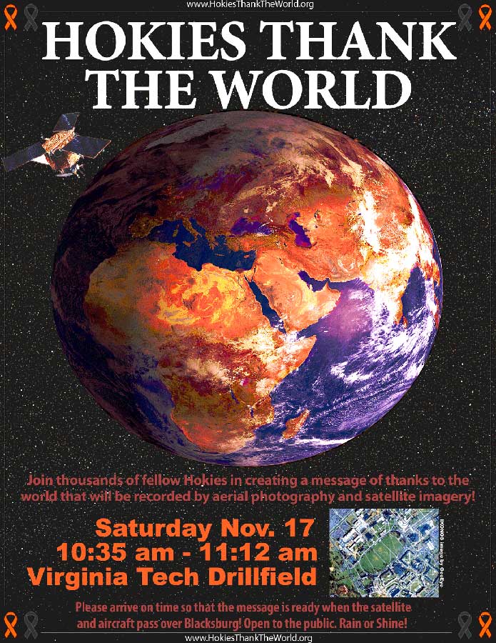
A "Hokies Thank The World" event will take place Saturday, Nov. 17, from 10:35 to 11:12 a.m. at the Virginia Tech Drillfield in Blacksburg., rain or shine.
The event will bring together thousands of students, faculty, staff, and friends to spell out a message of thanks to the world for the global outpouring of support for the Virginia Tech community following the events of April 16. The message of thanks will be recorded by ground, aerial, and satellite imagery and will be shared with the world at Hokies Thank the World website.
The community-wide effort to thank the world is open to all who wish to participate. In the event of cloud cover, the satellite imagery may not be collected, but aerial imagery will be collected as scheduled. Participants are asked to wear orange or maroon (not required), arrive by 10:35 a.m., and visit the check-in tent on the Virginia Tech Drillfield.
The Hokies Thank The World event takes place on the Saturday morning of the Virginia Tech vs. Miami football game in Blacksburg. The Hokies and Hurricanes kick-of at 3:30 p.m., in a game that will be televised by ABC. Aerial imagery from the event will be premiered in Lane Stadium during the football game.
“The world came together for the Virginia Tech community and the Hokies Thank The World event provides a way to send out a message of thanks and love to all of the world,” said Peter Sforza, VirginiaView coordinator and coordinator of the event and faculty member in the Department of Geography in the College of Natural Resources at Virginia Tech. VirginiaView is a statewide remote sensing consortium that promotes innovative applications of satellite imagery.
A diverse and talented team of students, faculty, staff, community members, and non-profit and commercial organizations have volunteered time and resources to assist in the planning and production of the event.
The Virginia Tech Student Government Association is sponsoring a media campaign on campus during the week of the event, including posters, flyers, table cards, a display in Squire Student Center, and a Facebook event.
The pilots for the aerial operations include a Virginia Tech professor using his personal helicopter and a Virginia Tech alumnus in a Hokie Flying Club airplane.
A bucket truck for field level photography will be provided by Mills Associated Arborists, a Blacksburg-based tree care company.
Videography and post-production assistance is being provided by HorseArcher Productions, the Blacksburg-based company best known for their production of Hokie Nation.
Event photography is being provided by Ivan “Russian Hokie” Morozov, Ty Brady, 16 Blocks Magazine, and Michael Kiernan from Virginia Tech's University Relations.
Virginia Tech's Center for Geospatial Information Technology (CGIT) has volunteered time and technology to help make this event a success. CGIT researchers have assisted with determining the accurate geospatial coordinates of the "VT Thanks You"' message on the Drillfield. "It is such a wonderful initiative that we felt compelled to help in any way we could," said Randy Dymond, CGIT co-director and associate professor of civil and environmental engineering.
The Department of Geography is the university sponsor for the event and will provide expertise and resources for the processing of the aerial and satellite imagery. A geospatial team made up of geographers, foresters, and engineers will work immediately following the event to process and release the imagery to the public. The processing of the helicopter and airplane photos includes georectification, which assigns spatial coordinates to the imagery and allows use with mapping and geographical information systems (GIS). The geospatial team will release the finished aerial imagery to the public as Google Earth KML files along with standard image formats.
The IKONOS satellite is operated by GeoEye, a Dulles, Va., based remote sensing company. The imagery will not be immediately available, but will be released as soon as it is transmitted back to earth and processed by GeoEye and then the Virginia Tech geospatial team. The exact timing of the satellite imagery release depends on the downlink location for the IKONOS imagery and is expected to be available by Thanksgiving day.
For information regarding the event, contact Peter Sforza at (540) 231-1867.
.jpg.transform/m-medium/image.jpg)