


Blacksburg Children's Museum and Virginia Tech showcase geospatial technology, weather
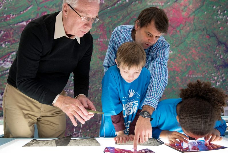
Visitors to the Blacksburg Children’s Museum now have a view of where they are in space and time thanks to an interactive geospatial exhibit with a wall-sized satellite image of the region and historical images of past decades. The new exhibit also includes a weather station displaying current and past weather conditions.
“This is our first exhibit that directly addresses our region with geography and weather. It’s amazing,” said Julene Rice, museum director.
Two faculty members and a doctoral student in Virginia Tech’s College of Natural Resources and Environment created the exhibit with support from VirginiaView, an outreach program. “We have been taking geospatial technology exhibits to the Virginia Science Festival, Kids’ Tech University, and various schools for years,” said James Campbell, professor of geography.
“We have a display with imagery, maps, and computers that offers interactive local scenes so kids can see the impact of a shopping mall, for instance, or can find their own house and look at the landscape 10 years earlier,” he added.
“We used images from Landsat, which is a series of U.S. scientific satellites that have been imaging the Earth’s surface for 40 years,” said John McGee, professor of natural resources management and a Virginia Cooperative Extension geospatial specialist. “The exhibit also builds on the online digital atlas of Virginia, which we developed to support Virginia’s educational community.”
When museum volunteer and board member Treesha Baird saw the exhibit at the 2014 Science Festival and the way it engaged children and their parents, she asked if the team could create a permanent display for the museum. “I realized there was a unique opportunity to involve the university with the community, to offer a resource not only for museum members but for teachers,” she said.
“We decided it would be an excellent activity for VirginiaView,” said team member Tammy Parece of Blacksburg, Virginia, a doctoral candidate in the college’s geospatial and environmental analysis program. “With satellite imagery, you have to get used to what you are seeing. If you start young, by the time kids get to college, they will be asking what else can we do — they will take it and run with it.”
“This is a regional museum so we wanted to showcase the region,” McGee said. “The image we selected for the wall mural contains myriad features: rivers and streams, highways, transmission lines, and mountain ranges. We want people to gain a regional perspective of their community and realize what a dynamic landscape this is.”
“The New River and the way the mountains lay are amazing features,” he continued. “The image could have been cloud free, but that is not representative of our region, so it includes clouds and cloud shadows on the landscape.”
VirginiaView funded the 15-foot by 10-foot mural of a Landsat image of Southwest Virginia and a 10-foot by 10-foot carpet that shows most of Virginia, with an interpretation key to assist understanding map features based on shapes and colors. Katie Britt of Memphis, Tennessee, a doctoral student in geospatial environmental analysis, designed the mural using remote sensing processing and image enhancement techniques.
The carpet includes the Chesapeake Bay because that is a vital feature of Virginia and the East Coast, McGee said. “Kids can gain an appreciation of Jamestown’s location relative to the New River Valley. They can begin to identify physiographic regions and different components of the Virginia landscape — beaches, the ocean, the bay, agricultural areas, and forests.”
New light tables provided by the Virginia Association for Mapping and Land Information Systems allow children to examine and mark smaller paper images of the region. Teachers can borrow the tables and images to use with lesson plans being developed by the VirginiaView team and the Virginia Geographic Alliance. Robert Oliver, assistant professor of geography, secured funding from the Virginia Geographic Alliance for the lesson plans and teacher training.
“The support and programming are invaluable,” said Rice.
The weather station was supported by a donation from Draper Aden Associates. Lucas Looney of Grundy, Virginia, a senior geography major, is guiding visiting students as they learn about the images and weather technology as part of a service-learning project.
“Weather grabs kids’ attention like you wouldn’t believe,” Parece said. “And it is a way to interest kids in science. For example, we can show them how weather out at the airport and downtown at the museum differ.”
Campbell added, “For her dissertation, Tammy put 11 new weather stations in Roanoke schools, so we already have lessons that show teachers and students how to use real-time data.”
“The goal is for kids to understand map imagery and relate it to their lives,” he continued. “This develops into understanding concepts of scale, how people use the landscape, and an understanding of their region.”
“The mission is to encourage a love of learning so children seek new learning opportunities,” Rice concluded.
The College of Natural Resources and Environment at Virginia Tech, which is ranked the top program of its kind in the nation, advances the science of sustainability. Programs prepare the future generation of leaders to address the complex natural resources issues facing the planet. World-class faculty lead transformational research that complements the student learning experience and impacts citizens and communities across the globe on sustainability issues, especially as they pertain to water, climate, fisheries, wildlife, forestry, sustainable biomaterials, ecosystems, and geography. Virginia Tech, the most comprehensive university in Virginia, is dedicated to quality, innovation, and results to the commonwealth, the nation, and the world.