Randolph Wynne earns national recognition for remote sensing applications in forestry
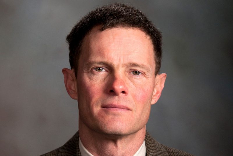
Randolph H. Wynne, professor of forest remote sensing in Virginia Tech’s College of Natural Resources and Environment, received a Society of American Foresters award recognizing his research in remote sensing applications that have resulted in significant advances in forestry.
In his nomination of Wynne for the society’s annual Award in Forest Science, University Distinguished Professor Harold Burkhart cited Wynne’s mastery of remote sensing topics, technically sound research, and eagerness to mentor students and recognize collaborators.
“Randy strictly adheres to the highest professional standards when developing and carrying out research projects, most of which are done in collaboration with others or with graduate students. His work has great scientific merit and is of tremendous practical value,” Burkhart wrote.
Wynne has been principal or co-principal investigator of research funding exceeding $7.5 million, most of which has come from competitive sources. His research has addressed two main themes: improving accuracy of land-use and land-cover classifications, and applying the remote sensing method LIDAR (Light Detection and Ranging) for forest monitoring and modeling.
Direct results of the research include better ways to identify forests, and the natural and anthropogenic changes that affect them, plus improvements to spatially explicit information that improves silvicultural decision-making.
“I guess all I ever had in mind from the start was to help our profession better understand, and thus manage, forests,” Wynne said. “It is gratifying to feel that I have made a difference.”
A prolific writer, Wynne has authored or co-authored more than 70 peer-reviewed journal articles that have garnered thousands of citations as well as “best paper” awards. In 2015-16 alone, he published 12 papers. He is the author of three book chapters and the co-author of “Introduction to Remote Sensing,” a highly regarded and widely adopted textbook.
“Relevance-wise, Virginia Tech is known as one of the global leaders in the applications of remote sensing to forestry, and our research and scholarship have helped shape the dialogue,” Wynne said. “Most important, of course, are the undergraduate and graduate students who have gone on to make a major difference themselves.”
Wynne has been the major professor for 23 completed master’s and doctoral students, with four additional students currently enrolled. Many have gone on to become highly productive researchers.
Burkhart described Wynne as “a sparkplug,” adding, “He has seen opportunities for development of remote sensing and geographic information systems for the College of Natural Resources and Environment and throughout the university.”
Burkhart cited as an example Wynne’s leadership in the development of the college’s Center for Environmental Applications of Remote Sensing. The center provides interdisciplinary leadership in remote sensing through formal instruction, outreach, cooperative research, and consulting. The center’s associated lab offers a full range of computer workstations for classes and research, including specialized systems for cartography, remote sensing, and geographic information systems.
In addition to his academic and research roles, Wynne actively engages in collaboration among researchers and practitioners around the world. A highly sought speaker on remote sensing, he has presented at numerous scientific conferences, technology transfer workshops, and meetings in the U.S. and abroad.
Wynne co-chaired SilviLaser, an internationally prominent biennial conference, at Virginia Tech for the first time in 2005. SilviLaser 2017, which he also co-chaired, drew 150 research scientists and practitioners from around the world to Virginia Tech in October. They came to hear keynote speakers and attend workshops on the development and application of LIDAR to improve understanding of forest ecosystem and forest assessment and inventory.
This month, Wynne joined a Virginia Tech delegation at the 23rd session of the Conference of the Parties to the United Nations Convention on Climate Change in Bonn, Germany. He and other members of his cohort reiterated the importance of remote sensing and modeling for improving transparency of nationally defined contributions toward the goals of the Paris Agreement.
Wynne, who has been a faculty member with the Department of Forest Resources and Environmental Conservation at Virginia Tech since 1996, earned his bachelor’s degree from the University of North Carolina–Chapel Hill and his master’s and doctorate from the University of Wisconsin–Madison.